Friday, April 24, 2020

Basketry Summer School in the 1930s - Musgravetown and Bonavista

I recently came across the following photographs in Memorial University's Digital Archives Initiative (DAI).  The first two are from Musgravetown, presumably in 1937. The photos are from the H.M. Dawe Photograph Collection of the United Church of Canada - Newfoundland Conference Archives.


The third photo is from Bonavista, taken two years previously. The photo is from the Maritime History Archive - Forbes Family Photograph Collection.


I'm not certain, but I suspect the Summer School in question was a training program for Newfoundland teachers, where they could acquire skills to take back to their classrooms in September.  Support for this comes from a clipping from the Western Star, 1936-05-06:


If you have information on this program or similar schemes to teach basketry skills in Newfoundland and Labrador, or photos of any baskets that might have been produced in this way, email dale@heritagenl.ca 

Heritage Update - New Designations, Virtual Museums, and Heritage post Covid-19


In this edition of the Heritage Update, Jerry Dick discusses Post-COVID-19 and Economic Stimulus – An Opportunity for Heritage; Michael Philpott introduces the new heritage designations; Dale Jarvis takes you on a virtual heritage tour of historic Bay Roberts neighbourhoods; and Andrea O'Brien gives an update on what's happening during the pandemic shutdowns.

Download the pdf here.

Friday, April 17, 2020

"I live in Bug Town" - Mapping out the heritage assets of Deer Lake


Before the Covid-19 lockdown, Heritage NL assisted the Town of Deer Lake with one of our People, Places, and Culture workshops, helping identify heritage assets in the community. The workshop involves people writing out recipe cards like the one above, noting things like placenames, historically interesting people, old shops and stores, or places where things used to happen. Then, we put them on a big paper map, and start to figure out clusters of places for future research and planning. I always love finding out some of the local informal neighbourhood names which you would never know if you didn't live there (like Bug Town!).

Since then, I've started to put some of that information on a Google Map, and have been compiling a list of names of people (past and present) who are of cultural or historical interest.  This is a very preliminary list, with a lot of gaps in it. If you have information on any of these people, or have suggestions for other Deer Lake people who should be included, email dale@heritagenl.ca or comment below.


Family NameFirst NameNotes
??War Veteran Farmers
BallRalphBlacksmith
Barrett?Store owner
BashaMike
BashaFrankie
Bearsley?Manager of Power House, wife was involved with Girl Guides possibly?
BolosDanBlacksmith
Brownie?farmer
ButtJoeGas station
ChaulkBillBowater superintendant
CoishAmosHarness maker in the 1930s
Critch?Store owner
CritchBeckyStore owner
CritchMoseStore owner
DinneyEliasworked as a carpenter on penstocks in early 1920s
Eddy?Store owner
FelthamAbrahamoriginal settler at Junction Brook, worked on Main Dam, farmer
Green(e?)TMFirst doctor
HaydenVictorhad second operation in Deer Lake hospital - appendix
Hinton?Mrs.?
HodderPhilRec Centre named for him
HousellMamielives on Hancock's Road, housed moved from Junction Brook, daughter of Abe Feltham
Hruse (?)?teacher
LungJimOwner of first Chinese restaurant in Deer Lake, on Main Street
McDonald?Doctor, made house calls, after hour visits, no set office hours for patients
MoreyMelvaGrade 4 teacher
MoreyDougfarmer
Nicols?Original settlers, farmers, fishing and hunting guides
Osmond?Store owner
Prowse?Had farm on Humber River near upper bridge
ReidAlexander (Sandy)towed houses from Junction Brook to Newtown in Deer Lake during the 1950s in preparation for the airport
SchwartzSamShop keeper, businessman. Job interview -you had to break the twine, if you broke it, you were hired
St. George?Hotel owner
Stuckless?Store owner, 5th Ave
WightHaroldLong time employee of Deer Lake Airport
Williams?Store owner


Wednesday, April 15, 2020

Carved By The Sea: Bay Roberts Virtual Museum project launches today!


The community of Bay Roberts is rich in local history and folklore. Today, a selection of its stories go online as part of Carved By The Sea, an exhibition developed by the Town of Bay Roberts Heritage Committee and Heritage NL, with an investment from the Virtual Museum of Canada.

European fishermen visited Bay Roberts as early as the 16th century. Fishermen from Brittany and Normandy fishing the waters off the coast of Bay Roberts in the early 16th century named the harbour Baie de Robert. They established onshore fishing rooms where they dried and salted codfish, most likely near the end of Bay Roberts harbour.

By the late 16th century, Bay Roberts had become part of the English Shore, and West Country fishermen began to settle in the area. Seary's Family Names of the Island of Newfoundland states that families with the surname French arrived circa 1634 and the Earles and the Badcocks arrived in the 1660s. Families such as the Parsons, Mercers and Bishops arrived later, and a further wave of settlers from the Channel Islands arrived in the 18th century.

“This website is a great opportunity to share the stories of this place,” says Heritage NL folklorist Dale Jarvis. “Some of the sites featured are well known, while others are special neighbourhood locations that might not be well-known outside of the community, and all of them are available in both English and French.”

This exhibition was supported by the Virtual Museum of Canada investment program under its Community Stories investment stream, which helps smaller Canadian museums and heritage organizations work with their communities to develop virtual exhibits that engage online audiences in the stories, past and present, of Canada’s communities. Fieldwork support was provided through the Helen Creighton Foundation.

Originally consisting of five smaller communities: Bay Roberts East, Bay Roberts, Coley's Point, Shearstown / Butlerville, and Country Road, the town was amalgamated into the Town of Bay Roberts on February 24, 1951. Today, the community is home to about 5,300 people and serves as a commercial hub in Conception Bay. It continues to be home to many long-term residents who keep alive the folklore and oral history of the town.

English:
Carved By The Sea

Français:
Sculptés par la mer

Monday, April 6, 2020

Where are the Looms? Help HeritageNL track down the province's looms and weavers.


A new group is turning to social media to track down some old technology - the wooden weaving looms that might be hiding in attics or basements somewhere in the province.

“A loom is the apparatus used for the purpose of weaving cloth,” says textile artist and researcher Jessica McDonald. “Its rudimentary principle is to hold threads under tension. Whether it be a floor loom, table top loom, or tapestry loom, its main purpose is to facilitate the weaver in creating a cloth”

McDonald is a recent graduate of the Nova Scotia College of Art and Design, who creates her own textile art, teaches, and researches weaving and craft in Atlantic Canada. She has recently created a woven piece for the “Newfoundland through a Window” Exhibition located at the Arts and Culture Center in Corner Brook.

McDonald’s work is the most recent chapter in a long history of weaving in Newfoundland and Labrador. From the days of the Grenfell Missions and the Jubilee Guilds, to the craft revival of the 1970s and the current makers movement, looms have been constantly busy in the background of the local craft scene.

“We want to find those old looms, some of which were hand-made, and figure out who the old weavers were,” says McDonald.

In addition to looking for old looms, the group is hoping to compile a list of living people in the province with weaving skills, as well as collecting old photos, stories, or memories of family members who used to weave.

“People who hold the knowledge of our various heritage crafts seem fewer in number, year by year,” says Heritage NL folklorist Dale Jarvis. “We want to document what has been lost, but also to record who still knows today how to make the tools and objects of yesterday.”

In response to what they see as a craft tradition at risk, Heritage NL has started up a Facebook group called “Weavers and Spinners of Newfoundland and Labrador” and will be hosting a “Where are the Looms?” online forum Thursday, April 9th at 11am, open to all interested in the textile heritage of the province, weavers and non-weavers alike.  The event is free, but pre-registration is required at www.heritagecraft.ca

Thursday, March 26, 2020

Living Heritage Podcast Ep171 Blacksmithing in Newfoundland


Photo of blacksmith Devon Hookey at work in the Green Family Forge in Trinity, NL. Photo by Dale Jarvis, 2019.

In this episode, Natalie Dignam talks about the history of the blacksmith trade in Newfoundland and forges you can visit on the island today, including the Green Family Forge in Trinity, Pinkston's Forge in Brigus, and an exhibit on Littlejohn's Forge in Bay Roberts.

Visit a Newfoundland Forge:

Littlejohn's Forge exhibit at the Road to Yesterday Museum


Dragon's head door knocker at the Green Family Forge. Photo by Dale Jarvis, 2019.


###

The Living Heritage Podcast is about people who are engaged in the heritage and culture sector, from museum
professionals and archivists, to tradition bearers and craftspeople - all those who keep history alive at the
community level. The show is a partnership between HeritageNL and CHMR Radio.
Theme music is Rythme Gitan by Latché Swing.

Wednesday, March 25, 2020

How old is the name Chain Rock? Older than you might think. #askafolklorist

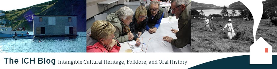
The approach to St. John's in 1813, by Chappell.


Dale Jarvis, Heritage NL

I love placenames, and over the past decade of intangible cultural heritage work, local names for places come up time and time again in our discussions of local history. Sometimes those discussions of toponymy pop up in unlikely contexts.

Earlier today, an online discussion of the word “lazaretto” - an isolation hospital for people with infectious diseases, especially leprosy or plague, or a building/ship used for quarantine - included a reference to quarantine procedures on Signal Hill in this quote from the Evening Telegram (St. John's, N.L.) of 1892-09-30:
There is access to it by water and on two sides by land, by a path from the lazaretto, which can be made good enough for a horse at the expense of ten dollars, and by a road from Chain Rock, which is not finished yet.
That quote raised the following question from Twitter user Rick Magill:
I always assumed chain rock got its name during WWII when they had torpedo/sub curtains across the narrows. Clearly much older. Anyone know how and why it got its name?
Historian Dr. Heidi Coombs was quick to respond, stating:
They referred to Chain Rock during the 1832 cholera quarantine, so it’s at least that old. Ships were not permitted to proceed into the harbour beyond Chain Rock.
She also shared the proclamation requiring ships to anchor at "the first Buoy within Chain Rock," from the Colonial Secretary's Office -- Quarantine Letters, 1832-26 (GN 2/17) at The Rooms.


Going back a bit further, we find a reference to Chain Rock in the long-titled work “Voyage of His Majesty's Ship Rosamond to Newfoundland and the Southern Coast of Labrador: Of which Countries No Account Has Been Published by Any British Traveller Since the Reign of Queen Elizabeth,” by Edward Chappell and published by J. Mawman in 1818.

In February of 1813, His Majesty's ship Rosamond, commanded by Captain Donald Campbell with Edward Chappell as his Lieutenant, received orders from the Admiralty. They were to repair forthwith to Cork, Ireland, in order to collect the first spring convoy bound for Newfoundland, Halifax, and the St. Lawrence River. This, they did, arriving first at Cape Broyle, and then heading to St. John’s.  Of their entrance into the port, Chappell wrote,
At about two-thirds of the distance between the entrance and what may properly be termed the harbour itself, there lies a dangerous shelf called Chain Rock; so named from a chain which extends across the street at that place, to prevent the admission of any hostile fleet. Mariners, on entering this place, ought to be aware of approaching too near the rocks beneath the light-house point. At the time we sailed by them, the masts of a large ship were still visible above the water, that had a short time before been forced by the swell upon those rocks, where she immediately foundered.
By 1813, the name Chain Rock was already well-established Historian Paul O’Neill summarized one version of history of the Rock in his book The Oldest City, published in 1975. He writes,
About 1770 a heavy chain was stretched across the Narrows from Chain Rock to Pancake Rock, and it was the duty of the troops to raise this chain each evening so that an enemy vessel or privateer could not sneak into the harbour under cover of darkness. During World War I a chain boom was again put into use. In World War II the Narrows were protected by a series of metal mesh anti-submarine nets.
1770, however, is not the oldest reference to Chain Rock. Former Parks Canada historian James Candow, in his book “The Lookout: A History of Signal Hill,” notes that a plan of St. John’s Harbour from 1751 includes the placename. He writes,
The same 1751 plan includes an early use of ‘Chain Rock’ to denote the navigational hazzard in front of the old North Battery site, and to which the chain of the Narrows boom had been affixed earlier in the century. [emphasis mine]

Archaeologist Steve Hull of the Provincial Archaeology Office pointed out an even earlier possible date. This map, "Plan du port et du fort de Saint Jean en l'Isle de Terreneuve, 1726"  shows a chain across at least part of the mouth of the Harbour (see detail below).


The map key in the upper-right records R as follows:


"la chaîne qui empêche l'entrée aux vaisseaux" - the chain that prevents entry to vessels.

So, the name Chain Rock goes back at least to the early 18th century. An earlier map of the harbour, drawn by David Southwood in 1675, notes the locations of both North Fort and South Fort, but not Chain Rock. Any use of the name earlier than the 1700s would, for now, be based on speculation. A research project for a future placenames researcher!

Local folklore aside, the name is definitely, and dramatically, older than the submarine nets of WWII.

Want to know more about NL archaeology and history? You can read Dr. Amanda Crompton's report on her 2008 fieldwork around Signal Hill, which included work near Chain Rock, starting on page 21 of the PAO Report

Friday, March 20, 2020

Living Heritage Podcast Ep170 Wyatt Shibley's Research on Newfoundland's Lebanese Community


Folklorist Wyatt Shibley. Photo by Natalie Dignam.

In this episode, Wyatt Shibley talks about his research on the Lebanese community in Newfoundland, including food traditions, material culture, and the big bands in St. John's, Newfoundlands that used to play popular music. Wyatt is a graduate student in the Folklore Department at Memorial University.


###

The Living Heritage Podcast is about people who are engaged in the heritage and culture sector, from museum
professionals and archivists, to tradition bearers and craftspeople - all those who keep history alive at the
community level. The show is a partnership between HeritageNL and CHMR Radio.
Theme music is Rythme Gitan by Latché Swing.

Photographs from Bowring Park, St. John's, taken in the 1930s.

Bowring Park in St. John's was officially declared open on July 15, 1914 by His Royal Highness the Duke of Connaught. At the opening, the Duke hoped that "May it ever be a source of pleasure and enjoyment to the citizens of St. John's and to Newfoundland in general."

These 1930s-era photos are from a collection donated by Ruth Noseworthy Green, and for the most part feature the family of Arthur Taylor, of Southside, St. John's.

Arthur Taylor, 1932

Bowring Park, 1932.  

Max and his brother Arthur Taylor in Bowring Park, 1936.


Arthur Taylor, 1932, Bowring Park Boat Pool and Wharf.

Bowring Park Boat Pool, 1932. 

The "Boat Pool" or "Boat Lake" is now known as the Duck Pond. It was designed by landscape architect Rudolf H. Cochius and completed in June, 1913.  If you look very closely at the centre of the above photo, you can make out a small octagonal building:

Bowring Park Boat Pool, 1932, detail, sharpened.

Could this structure be an early duck house? In 1946, the park became home to six white swans, and a Chinoiserie-style octagonal Swan House was constructed, which you can see clearly in the photo below of the Boat Pond from 1946, taken from the History of Bowring Park.

Boat Pond, 1946, possibly by TB Hayward.


Do you have an early photo of Bowring Park? Email me at dale@heritagenl.ca